Some Recent Projects
|
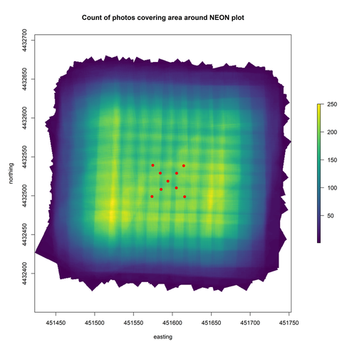
Democratizing macroecology: integrating unoccupied aerial systems with the National Ecological Observatory Network
University of Colorado-Boulder; NEON; Boise State University With Victoria Scholl, Anna Spiers, Megan Cattau, John Adler, and others, we are working to connect drone-derived data to data already collected by the National Ecological Observatory Network (NEON). By providing a framework and an open workflow, we aim to lower the barrier entry to using drones to do forest ecology. This work was recently accepted in Ecosphere. Drone-derived data can have enormous value-added to the existing Observatory network by expanding the spatial extent or temporal resolution of data collection. Often, these augmented scales are critical for understanding forest processes like disturbances, which requires opportunistic sampling that may not align with the spatial or temporal schedule of NEON sites. Integrating opportunistic drone-based sampling of management-critical phenomena with NEON's observations multiplies the value of both efforts and can hone the relevance of NEON for stakeholder decision-making. Accepted text here GitHub repository here Open Science Framework repository here |
|
Cross-scale interaction between host tree size and climatic water deficit governs bark beetle-induced tree mortality
University of California, Davis; USDA Forest Service
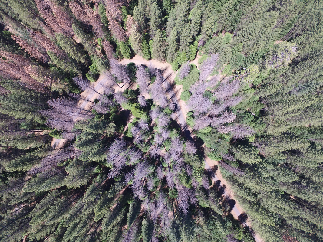
I worked with Dr. Chris Fettig of the USDA Forest Service to document the spread of the western pine beetle along a 350 km latitudinal gradient and a 1000 m elevational gradient in the Sierra Nevada of California. The western pine beetle is a 'primary' bark beetle that attacks and kills live ponderosa pine trees (its host) in order to reproduce. The climate change-type drought in California from 2012-2016 created conditions that favored rapid beetle population growth and expansion of these native tree predators.
We used drone surveys across a network of field plots, covering a total of 9 square kilometers of forest and taking over 450,000 photos, which allowed us to generate three-dimensional models and orthomosaics of the forest using a technique called structure from motion photogrammetry. Using these photogrammetry-derived products, we are able to measure and classify the trees in a 30-hectare area around each of 32 sites.
We found that both broad-scale environmental conditions and local scale forest structure and composition were strong predictors of host tree mortality. Higher historic climatic water deficit, a greater local proportion and density of host trees, and larger trees all increased tree mortality rates. We also found a strong interaction between tree size and climatic water deficit. Larger trees were particularly strong drivers of mortality in hotter/drier sites. This finding challenges our understanding of western pine beetle outbreak dynamics and shows that climate change adaptation strategies should expect cross-scale interactions to play a role in disturbance outcomes as those disturbances become more frequent and intense with climate change. This piece of this project is now published in Nature Communications.
One future direction for this work is to use information about the size and distribution of attacked trees to parameterize an agent-based model that we can then use to simulate western pine beetle outbreaks in forests with different tree densities and sizes.
The final version is now published in Nature Communications here.
The GitHub repository is here.
The Open Science Framework repository, including nearly 1.5 TB of open data is here.
University of California, Davis; USDA Forest Service
I worked with Dr. Chris Fettig of the USDA Forest Service to document the spread of the western pine beetle along a 350 km latitudinal gradient and a 1000 m elevational gradient in the Sierra Nevada of California. The western pine beetle is a 'primary' bark beetle that attacks and kills live ponderosa pine trees (its host) in order to reproduce. The climate change-type drought in California from 2012-2016 created conditions that favored rapid beetle population growth and expansion of these native tree predators.
We used drone surveys across a network of field plots, covering a total of 9 square kilometers of forest and taking over 450,000 photos, which allowed us to generate three-dimensional models and orthomosaics of the forest using a technique called structure from motion photogrammetry. Using these photogrammetry-derived products, we are able to measure and classify the trees in a 30-hectare area around each of 32 sites.
We found that both broad-scale environmental conditions and local scale forest structure and composition were strong predictors of host tree mortality. Higher historic climatic water deficit, a greater local proportion and density of host trees, and larger trees all increased tree mortality rates. We also found a strong interaction between tree size and climatic water deficit. Larger trees were particularly strong drivers of mortality in hotter/drier sites. This finding challenges our understanding of western pine beetle outbreak dynamics and shows that climate change adaptation strategies should expect cross-scale interactions to play a role in disturbance outcomes as those disturbances become more frequent and intense with climate change. This piece of this project is now published in Nature Communications.
One future direction for this work is to use information about the size and distribution of attacked trees to parameterize an agent-based model that we can then use to simulate western pine beetle outbreaks in forests with different tree densities and sizes.
The final version is now published in Nature Communications here.
The GitHub repository is here.
The Open Science Framework repository, including nearly 1.5 TB of open data is here.
Local forest structure variability increases resilience to wildfire in dry western U.S. conifer forests
University of California, Davis; USDA Forest Service
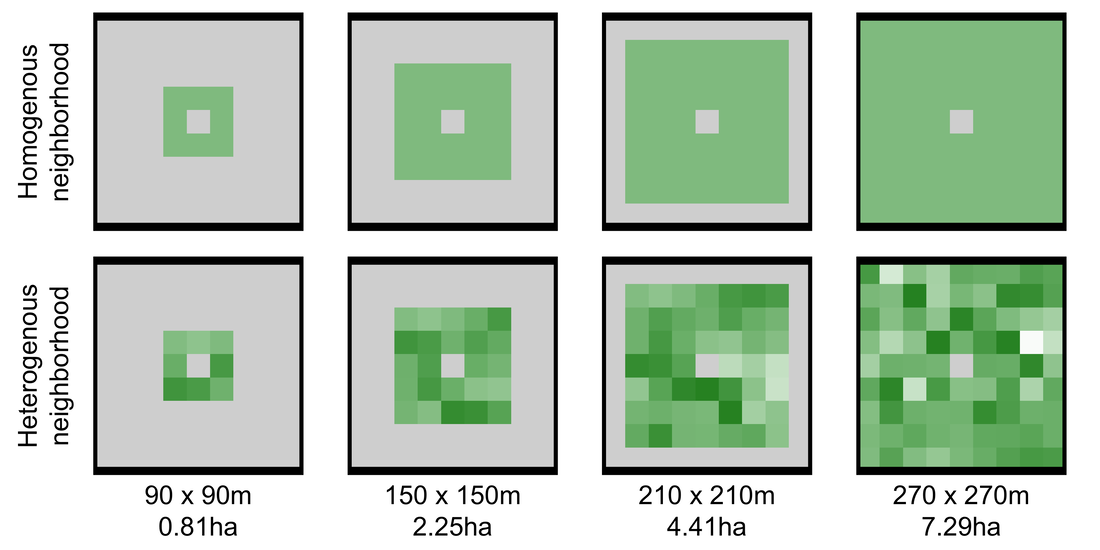
Malcolm North, Chhaya Werner, Stephen Fick, Andrew Latimer and I developed an approach to quantify wildfire severity and local-scale forest structural variability for over 1000 fire events in California's Sierra Nevada mountain range. We found that greater variability in forest structure reduced the probability of high-severity wildfire at a system-wide scale. This represents a feedback that links past and future disturbance via forest structure and suggests that management action that restores forest structure variability has a better chance of promoting long-term forest persistence because it harnesses this feedback. This work was recently accepted in Ecology Letters, and the submitted version can be found as a preprint on EcoEvoRxiv.
We used Google Earth Engine for this effort, which is a cloud-based GIS. The promise of this approach is that we can write and upload javascript code with our analyses and then outsource the computationally intensive image hosting and processing to Google. With this effort, we also released a new dataset of wildfire severity for the Sierra Mountain range which more than doubles the number of fire events that have a severity assessment compared to the previous regional standard.
The final version is now published in Ecology Letters here.
The GitHub repository is here.
The new fire severity dataset that we generated is on the Open Science Framework here.
University of California, Davis; USDA Forest Service
Malcolm North, Chhaya Werner, Stephen Fick, Andrew Latimer and I developed an approach to quantify wildfire severity and local-scale forest structural variability for over 1000 fire events in California's Sierra Nevada mountain range. We found that greater variability in forest structure reduced the probability of high-severity wildfire at a system-wide scale. This represents a feedback that links past and future disturbance via forest structure and suggests that management action that restores forest structure variability has a better chance of promoting long-term forest persistence because it harnesses this feedback. This work was recently accepted in Ecology Letters, and the submitted version can be found as a preprint on EcoEvoRxiv.
We used Google Earth Engine for this effort, which is a cloud-based GIS. The promise of this approach is that we can write and upload javascript code with our analyses and then outsource the computationally intensive image hosting and processing to Google. With this effort, we also released a new dataset of wildfire severity for the Sierra Mountain range which more than doubles the number of fire events that have a severity assessment compared to the previous regional standard.
The final version is now published in Ecology Letters here.
The GitHub repository is here.
The new fire severity dataset that we generated is on the Open Science Framework here.
Masters thesis work

The eco-evolutionary consequences of multiple introductions for colonizing individuals
Colorado State University
What factors influence the ability of a population to persist in a novel habitat? Whether we’re trying to understand what makes an invasive species successful, reintroduce a rare species to its former range, or effectively release a biological control agent, understanding the fate of introduced populations is critically important. Also, because of its relevance to a broad array of stakeholders, this kind of research presents an excellent opportunity for ecological and evolutionary theory to unite with application and guide resource management practices.
Propagule pressure, comprising the number of introduction events to an area as well as the number of individuals introduced per event, emerges as arguably the only common predictor of successful introductions. But which component is more important? Theory suggests that the degree of variability in the environment might affect the answer to this question, but experimental work is needed to validate these hypotheses.
I'm using the Tribolium flour beetle as a model system to experimentally test the importance of multiple introductions on founding success in both stable and fluctuating environments. By understanding how multiple introductions and environmental variability play into the persistence and evolutionary trajectory of an introduced population, we will hopefully be able to make more informed population management decisions on the ground.
The paper for the first part of this work was published in Ecology and Evolution: Parsing propagule pressure: Number, not size, of introductions drives colonization success in a novel environment
